Saturday, April 27, 2019

Flood Defences: South Ferriby

Flood Defences: South Ferriby

As a result of the continued threat from flooding, and in particular the devastating tidal surge of 2013, steps have been put in place to strengthen the flood defences at South Ferriby. Great losses occurred in December 2013, when 129 properties and 1,000 hectares of land were flooded, with an estimated £50m worth of economic loss to the area.

Temporary defences were put in place in 2017 along the A1077 (which runs along the Banks of the Humber and over the River Ancholme at Ferriby Sluice) due to the threat of further tidal surges and breaches of the river bank.

 
Temporary flood defences, 2017
However, a £15 million flood defence scheme to help protect homeowners and businesses in South Ferriby has now been drawn up by the Environment Agency. It is part of a £40 million investment by the government  provided in July 2018 to deliver this scheme and others across the country to address the increasing threats from global warming and rising water. The Environment Agency scheme will help to protect land in the vicinity of Ferriby Sluice,144 homes and agricultural land, as well as the CEMEX cement plant and the Hope and Anchor pub at the mouth of the Ancholme river. The government funding will also help the Environment Agency unlock millions of pounds worth of partnership funding for the South Ferriby Flood Alleviation Scheme.


South Ferriby Flood Plan 2019
https://lincolnshirereporter.co.uk/2019/03/1-9m-south-ferriby-flood-defences-to-get-green-light/

The proposals would see a new impermeable flood embankment west of the CEMEX Plant, and improvements to the north of the A1077 where the embankment will be raised. New brick clad walls would be built in the area around Ferriby Sluice and defences would be placed across the A1077 when flood warnings are issued. The plan received approval on 13th March, 2019 and work has now commenced.


Work commences 22 March, 2019

Site visits

Since the work commenced I have visited the site on a number of occasions to see what the works entail and the effect on the local landscape. I have walked the route of the new defences, along part of the embankment which has now been done, and seen the work started at the CEMEX plant. I have recorded progress so far with my camera throughout the end of March and April, 2019.


Defences A1077
 
 
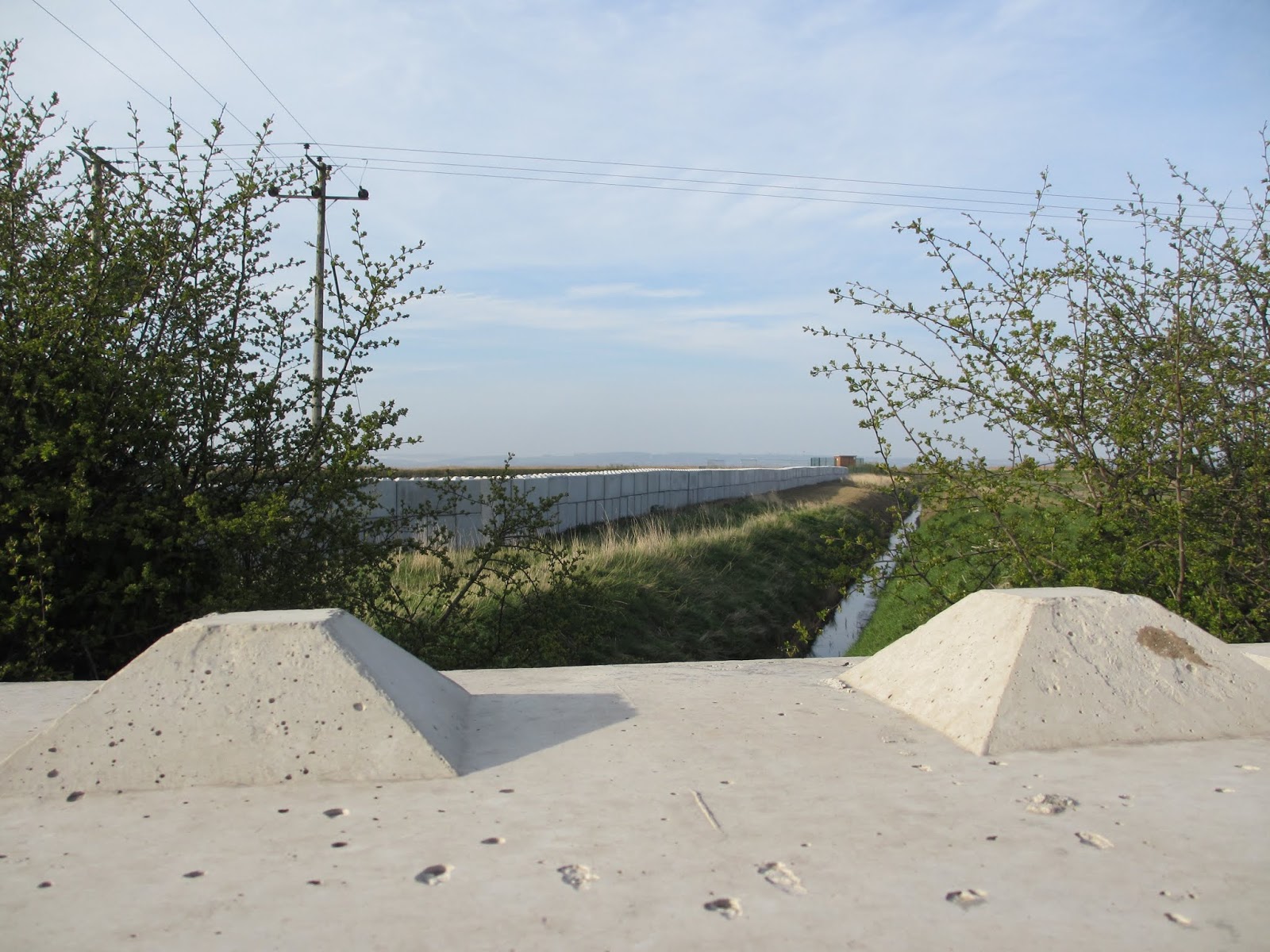
Looking towards the Humber
 
 
Walking towards the Humber from the A1077
 
 
View from the Humber
 
 
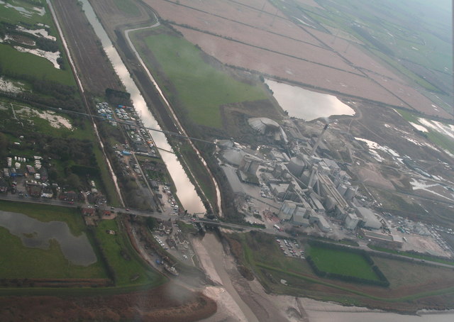
Layout of Works, CEMEX Plant


  Building of banks, CEMEX


Work in progress, CEMEX - views from the west
 
Relevance to my work
 
Landscape
 
It can be seen from the above images that the current flood defence works are having a huge impact on the landscape. Hard edges of concrete blocks now lead the way to the Humber embankment. Areas of former agricultural land have made way for the building of embankments and other defence works can be seen at the CEMEX site. I am now able to compare photographs taken before these works and after, and undertake a visual impact assessment. Below is a photograph I took in October, 2018, at that time I was not aware of the defence plans for this area. However, we can now see how the previous agricultural "plain" has been used to create the site for the embankments and defences to protect the Cement works, its car park and football pitch from further devastating floods.
 
 
Similar view of the CEMEX Plant, October, 2018
 
 
Tidal Surge and Drought
 
My experience of walking along the Ancholme and the banks of the Humber at South Ferriby make me feel very close to the water. It cannot be ignored. Sometimes it gushes in at high tide, and at other times it retreats, leaving boats marooned on muddy banks. It swirls around obstacles in its way and one becomes aware of its unending power which people try to control. I have made some images already of different tidal conditions and aim to continue to do so as I am interested in the battle of the elements and the effect on the landscape.
 
 
 Water swirls around ruined jetty (submersed at high tide)
 
 
Water retreats along muddy banks
 
However, as I have walked along the river banks and the new concrete blocks which form the river defences, I cannot help but see (incongruously) how dry and baked the earth is. Large cracks have appeared along the walkway, and I wonder about how not only does climate change entails floods, but droughts as well. We often go a long time without rain and summers can now be quite hot. I took some photographs of the parched earth along the embankment to illustrate my point.


Dry baked earth along the embankment
 
Future Works
 
I am thinking about how I can translate some of the power of  water, the wet, sticky mud of low tide and the hard, dry baked earth. I will look back at my previous experiments with materials and get ideas as to how I can depict these aspects of my research and put my thoughts into practice - it is a fascinating area to consider. Another aspect of my practice may be how the soft, natural aspects of the landscape contrast harshly with the new bulky forms of the man-made flood defence structures, and I will consider these thoughts further as I progress.


History of the Ancholme River: Drainage and Commerce

History of the Ancholme River: Drainage and Commerce

Ferriby Sluice

The River Ancholme enters the River Humber, which forms the boundary between Lincolnshire and Yorkshire, through a sluice completed in 1844 by Sir John Rennie at the hamlet of Ferriby Sluice just outside South Ferriby. The image below was taken approaching slack water with the sluice gates slightly ajar to regulate the water level in the marina on the River Ancholme, a river which has long been used as a navigation and drainage channel.
 
The sluice itself is Scheduled under the Ancient Monuments and Archaeological areas Act, 1979 as being of national Importance.


Historic England, Ferriby Sluice, Scheduled Monument No. 1005244
 
Navigation

  
The navigation of the river and its relevance to the local economy can be traced back to the Iron Age.
A giant prehistoric boat and a causeway were discovered near the Ancholme during construction work in the late 19th century, showing that the area had been inhabited during ancient times.
Discovery of a log boat near Brigg, 1866
 
As recently as 1981 a further ancient log boat was discovered and is now preserved at the archaeological Museum at Lincoln, The Collection, which I recently went to visit (below). 


Brigg
The Ancholme was usually navigable to the market town of Brigg, allowing trade with many areas, particularly in timber and agricultural products.
Back in the 11th century the only crossing was by wading through a ford where the river was just a few feet deep. A very small settlement was clustered near the crossing point. The first recorded reference to the county of Lincolnshire was in 1016 and the area was surveyed by the Domesday Commissioners after the Norman Conquest. Few people lived in the tiny hamlet and were probably involved only in a little agriculture, fishing and wildfowling. The meandering river was connected directly to the tidal Humber and the district was subject to frequent flooding, particularly during the winter. Brigg really came of age in 1205 when the first Thursday market and two fairs a year were established by way of Royal Charter.

Improvements, Drainage and Trade

There are records of improvements to the river to improve drainage and alleviate flooding from as early as the thirteenth century. The river now runs in two channels known as the "Old River Ancholme" and the "New River Ancholme", the latter being the result of a local landowner cutting a straight drainage channel in 1635 to help take the waters of numerous becks out to the River Humber, whilst the old "Old River Ancholme" follows its natural course..

The arrival of turnpike roads was also a boost to improved communications and trade on which Brigg relied. Methodist pioneer John Wesley visited Brigg in the late 1700s and described it as “a noisy, turbulent town.” In 1794 Brigg Fair attracted 200 people from Hull by boat and historic buildings dating from the 18th century still survive today.

Sir John Rennie’s work on improving the drainage of the Ancholme, including Ferriby Sluice in the 1820s, meant that traffic along the river expanded significantly, particularly to Hull, with regular steam packet services from Brigg carrying cargo of many kinds.


Brigg Marketplace in 1836
 
Horkstow Bridge
Rennie was also responsible for the design of an early suspension bridge which spans the New River Ancholme at Horkstow, about 1.1 miles (1.8 km) upstream from Ferriby Sluice. It links the villages of Horkstow, east of the river, and Winterton on the west. A ferry had previously connected the villages, and it is believed a bridge had occupied the site from the 18th century, providing access to  brick-making kilns located on the west side. The bridge was open to vehicles until recently, but movement can be felt even under pedestrian traffic. It is now mainly used by walkers and cyclists. It can be approached from the east via Bridge Lane, just north of Horkstow, but on the west bank only a dirt track remains. Horkstow Bridge is a Grade II* listed building, which is testament to Rennie's design and marks its historical importance to the local infrastructure and commercial requirements.
Horkstow Bridge
 
Relevance to my work
My research into the history of the River Ancholme has enabled me to put the importance of managing the river, its drainage and importance to the local economy into context. The recent tidal surge and floods are not only a constant threat to the area now, but have been an issue for many years, as the works by Sir John Rennie demonstrate. The fact that such an important engineer was called in to design the sluice and suspension bridge is good evidence to say that the Ancholme River played a vital role in local trade and had to be kept open and navigable. The threat from high tides and the difficulty of draining such low-lying land had to be kept in check from its earliest days.
Much of what I have described above is still visible today. Many of the works I have made so far involve the landscape around the sluice and the outlet of the river into the Humber Estuary. I have also made prints and paintings of the diverted river and objects surrounding it. I have visited the archaeological museum at Lincoln and seen the log boat referred to above and other Iron Age and Roman remains. I have visited Brigg and seen for myself the historic market place and many Georgian and Victorian buildings which still survive. I have walked across the ancient wooden boards of Horkstow Bridge and taken many photographs. It is a quiet backwater and it is difficult to imagine the important role that the bridge played at the time it was built.
In summary, the threat of flooding to the area and the importance of keeping the channel open for trade sets in place the historical context of the river. I feel that the aspect of "time" and the use by humans of the land and waterways plays a large part in my practice and interests, especially as global warming and climate change can have such devastating effects .


Friday, April 26, 2019

Climate Change : Tidal Surge South Ferriby

Climate Change: South Ferriby


As I have walked around South Ferriby and the River Ancholme I have become significantly more aware about the environment, and in particular about the threats to the area from flooding. I saw evidence of recent floods at the Marina, as I mentioned in my previous post.

I have followed up these observations with research, which has illuminated how the whole area of South Ferriby, Ferriby Sluice and the Cement Works were devastated in 2013 by a massive tidal surge - the worst seen in sixty years.

Global Phenomenon

I do not wish to go into the causes for climate change in detail, or the politics surrounding the issue, but it is a very topical and emotional subject at the moment. Countries all over the world are grappling with the problem and activists have sprung up to bring attention to the need to act. For example,
Extinction Rebellion is a socio-political movement which has undertaken many days of protests across London during April this year and has successfully raised the profile of their aims. They uses nonviolent resistance to protest against climate breakdown, biodiversity loss, and the risk of human extinction and ecological collapse.

https://www.youtube.com/watch?v=HDhNORiTtOU

 On one occasion they protested in the public gallery at the House of commons and in another, outside the London Stock Exchange. they brought central London to a standstill and about 1,000 people were arrested. During the same period teenage environmentalist Greta Thunberg addressed the crowd.

https://www.euronews.com/2019/04/23/mps-welcomed-by-extinction-rebellion-on-their-return-from-easter-recess


https://www.image.ie/life/greta-thunberg-uk-mps-generations-stolen-147571

Tidal Surge - South Ferriby, 2013

South Ferriby suffered great losses in December 2013, when 129 properties and 1,000 hectares of land were flooded, with an estimated £50m worth of economic loss. The Cement Works were swamped  and caused the plant to be closed for twelve months. People were evacuated from their homes and had to abandoned cars to escape the rising waters.

During my research I have found many images of the devastation caused.

 
Ferriby Sluice Aerial View, 2016
geograph.org.uk
 
CEMEX Cement Works, 2013, car park and football pitch.


Fire and Rescue Services at the site of the "abandoned jetty", South Ferriby,  6 December, 2013
 
 
Relevance to my work
I am aware of these locations at South Ferriby - which forms my case study. Some of the places and objects, such as the "abandoned jetty," have been the subject of some of my prints and paintings. Although I have started to investigate the Marina, I intend to explore the devastation caused to the boats there further as part of my practical work.
The concept of the way that mankind has used the planet and its resources to further trade, commerce and lifestyle choices fits well within the concepts that I am exploring.
Following the floods in 2013, steps have been taken to alleviate the threat from further tidal surges, and I will also be researching and recording what is being done in relation to strengthening local flood defences.


Sunday, April 14, 2019

Concepts and Practice

Concepts and Practice.

My post of 8th March 2019 sets out my Practice Statement at that time. I am keeping my ideas under review as I do more research and undertake further practical exploration. I think that at this point it is relevant for me to consider the direction of my ideas and refresh my thoughts.

I have refined the wording of my Practice Statement so that it currently reads:

"I am interested in how human activity relates to and interacts with the natural landscape. Industry, housing and leisure impose themselves onto the landscape but nature will find ways of fighting back and surviving. Things left behind get taken over, plants and trees blend in to soften edges and balance an otherwise hard landscape. It is this concept and process which informs my practice."

I think that my work so far reflects many of these elements and thought processes. Examples illustrated in previous posts and displayed in my studio include works around the following topics which employ various methods and materials:

- Cement works South Ferriby/ locks/river
- Abandoned jetty
- Site of diverted river with drainage pipe and overhead factory chute
- Old boats and jetties
- Old ropes and driftwood
- Factory amid natural setting (trees/buds/ blossom/daffodils)
- Natural objects (hips/haws)
- Wildlife (heron/ducks)
- Things left behind (old post, bollards, snapped moorings)

Some further examples are illustrated below:


Human Activity over time and Climate Change
 
However, as I read more and make further visits to the site I am thinking of wider and bigger issues. My post of 26th March contains the following extract:
 
 "I am  continuing to develop my theme on the relationship between human activity and the natural landscape. When nature is under threat from industrialisation, re-development and natural disasters, such as those caused by climate change, it is important to consider how plants still manage to survive, thrive, and make a difference to an otherwise bleak and harsh landscape. They spring from nowhere, find cracks and crevices, grow up and around abandoned industrial machinery and things left behind. As changes take place, they provide a constant reminder of nature's resilience."
 
In the above paragraph I refer to the relationship between human activity and the natural landscape and the threat from climate change. I think about how plants generally can often survive harsh conditions, but what if the landscape cannot survive the overall effects of global warming?
 
As I have walked along the river bank and outlet to the Humber Estuary I have seen evidence of previous floods. This was especially apparent during walks around the marina. Boats lie abandoned in the yard, some under tarpaulin, and due to water damage will never sail again.
 
I thought about the devastation floods (and droughts) cause.
 
The first sentence of my Practice Statement states:
 
"I am interested in how human activity relates to and interacts with the natural landscape."
 
I think therefore that it is a natural consequence that I should make it clear that my practice includes the consideration of the effect of human activity over time and the threat of natural disasters from climate change.
 
I will review my Practice Statement and the scope of my practical work in that light.


Marina with boats damaged through flooding.


Saturday, April 13, 2019

Exploring Materials: "Sugar Lift"

Exploring Materials: "Sugar Lift"

I had heard of the printing process called "sugar lift". A "lift" as a ground enables you to make positive marks onto the plate which, when placed in the acid becomes the bitten part of the image. I had been told that it creates a "painterly" effect as the sugar lift solution is painted directly onto the plate. The plate is first de-greased and then laid with a ground.The sugar lift is a saturated sugar solution which contains some soap and a little paint or drawing ink to give it colour so that you can see the image you are creating on the plate. Sugar lift can be bought ready made from print-making suppliers or you can make your own.

I decided to begin with an easy topic as I was experimenting with something completely new. I also wanted to choose the material for a plate which resonated with the subject matter, so that the concept linked with the method I was using. I thought about my ideas on "things left behind" and some of the objects I had seen at South Ferriby - for instance, the links with sailing and days gone by. I had in mind an old metal post that I had seen set on the river bank at the edge of undergrowth and a wooded area. I chose that as the subject matter and found a small piece of steel to work on. The steel married up with the concept of the old metal post.

The Process

These are the stages that I went through to create my sugar lift image:


After painting the image onto the prepared plate with the sugar lift solution, I immersed the plate in warm water.


I gently washed the warm water over the surface of the plate with a brush to help "lift" the sugar solution.
The image began to emerge.
 
I took the plate out of the water and dried it. The image which I created with the sugar lift solution can be seen.
I then painted on a "stop out" to create lighter areas and put the plate into nitric acid to etch.
The finished print.
 

Outcome
 
I think that the finished plate does have a very "painterly" look. There is a soft defined edge to the lines, with good tonal and highlighted areas. The print has a lot of character and it suited the subject matter of an ancient rusty post in a semi-wild setting, giving a mood of abandonment and mystery.
 
Future Use
 
I will try this method again to achieve soft, moody images with lots of character. It will suit that part of my practice which deals with a sense of days gone by, and other more fluid interpretations of both natural and hard landscapes. As I have only done this process once, I feel that I need a few more practices to really get to grips with the process and its potential. I consider that my practice lends itself to this process, both in the subject matter of my interests and the sort of image I like to create. It was appropriate to work on steel, seeing that the post was made of metal, and I think that aspect added to the success of the outcome. In this way, it links up with my research and Mandy Payne's use of concrete.
 

Tuesday, April 9, 2019

Exploring Materials: Perspex

Exploring Materials: Perspex

I decided to explore further what materials may be more suitable than metal for the natural elements of landscape. I felt that prints made from both steel and aluminium plates could have a hard edge to the finished results. For instance, it is quite difficult to produce a natural curve on metal as sometimes the tool makes an inadvertent "spike" in the metal as it moves around corners. I became more aware of this as I etched the daffodil print, where I was making flowerheads on quite a small scale. I had used Perspex before for dry point etching and decided to specifically try it out for some more delicate, floral scenes which I had seen at the South Ferriby site. The area surrounding the cement works, locks and river bank are surprisingly full of flora and fauna. I give some examples of the experimentations I did below.

Hips and Haws

As you walk along the former tow path alongside the river's edge, there were many examples of rose hips and haws(hawthorn berries) twining around any structure they could find, or just supporting themselves and appearing in arches from the undergrowth. It was interesting to compare the different shapes. The rose hip berries were more elongated, while the haws were rounder. I decided to make prints of both types of berries to capture the essence of the wildness of the river bank, and to compare and contrast the two types of berries and foliage.

I bought two pieces of multi-purpose Perspex to explore their qualities.

I found that the dry point needle moved readily through the Perspex and it was easy to move the tool around the curved shapes of the berries and leaves, even though they were on a relatively small scale.

Hips
Haws


Cherry Blossom and Factory Scene

As Spring developed, the scene changed and blossom started to appear along the bankside. It was a refreshing sight, and I thought that to make a print of the delicate blossom flowers set against the starkness of the factory in the background would be a good chance to explore the different qualities of the Perspex for soft and hard landscape.

The blossom also sat alongside other features of the walk along the river's edge, and I decided to include some posts, fencing and gates to add narrative.

I chose a large piece of Perspex for this work. As above, I found that the dry point needle was very handy for the small, intricate lines needed to capture the delicate blossoms flowers which I observed However, I found that I could also use the tool quite well on the plastic for the larger, more formal lines required for the fencing and factory outlines. Close straight lines and some cross hatching enabled me to capture some tonal elements, and I used tissue paper and cotton buds to remove more printing ink where I wanted to add highlights.

Outcome.

The prints of the hips and haws are very well defined. Because I was concentrating on defined sections of branches and on fairly small pieces of Perspex, I was able to concentrate on really working on the different shapes of the berries and foliage, working into the plate and being able to emphasise their form and structure.

The larger print of the blossom scene has a number of different elements. The blossom flowers themselves suited the use of the Perspex. I was able to use the dry point needle in an effective way to capture the flimsy heads of the flower heads. At the same time the material allowed me to portray the harder industrial setting of the factory in the skyline, and also the hard edges of the features alongside the path, such as posts and fencing.


Blossom Scene


Future Use

I consider that my exploration of the qualities of the Perspex for both hard and soft landscape elements worked very well. My experiments proved that the Perspex plates were flexible enough for curvy , delicate lines that had movement, and also for long, straight lines, tonal areas and hard edges. The prints, have a light, airy feel about them as I was able to clean the Perspex very well after inking up, which meant that I could obtain a good finish which allowed the white printing paper to be exposed (unlike the steel -very dark image, and the aluminium - quite a dark image). The Perspex provided a defined "burr" to the lines which is very attractive (more so than the steel and aluminium). The only disadvantage I found was that the Perspex plate wore down after about five prints, so a long run of prints is not possible as the quality deteriorates, the more times that the plate goes through the printing press. My conclusion is that the Perspex is a very versatile medium and can used for a number of different purposes.


Monday, April 8, 2019

Exploring Materials: Aluminium

Exploring Materials: Aluminium

Following my experimentation with the use of steel, I also thought that the use of aluminium as a plate for printing would work well with the idea of the metallic finish of the cement factory. The use of the metal would make a contrast between the man-made structure of the factory and the surrounding natural landscape, emphasising how nature works in harmony with it.

The use of aluminium has the advantage that the metal is quite soft. This means that it is relatively easy to work direct into the surface with etching tools using the technique called "dry point etching". Dry point etching does not involve any use of chemicals.

I made two experiments.

The first image is a view of the factory complex looking over a linked metal fence. In the foreground are some over-hanging branches and some overhead electric cables. I felt that this view captured the industrial feel of the landscape as it incorporated  a mix of typical features that one usually sees in such a setting. The leaves on the branches were well defined and lent themselves to a good line drawing. I achieved some darker tonal areas by the heavier use of the etching tool and cross hatching. This meant that when I applied the ink to the aluminium plate the ink collected inside the grooves to make the darker areas. I used tissue paper and cotton buds to lighten areas on the factory buildings and fence to accentuate where the light was falling.


The second image is a more delicate scene including a group of daffodils on the river bank opposite the factory complex. It includes mooring posts which run along the edge of the river, and is seen from a low viewpoint. The same technique was used as above. I have included below a photograph of the finished plate and the tools I used. It can be seen how thin and shiny the aluminium metal is to work on. This can be contrasted with the thicker, heavier and duller steel I used in the previous post.
 
 
Above: aluminium
 
Above: steel (detail)
 
Outcome
 
I was satisfied with the two prints I made on the aluminium plate. The metal was easy to work with and straight forward, as I did not have to use acid. The line made with the etching tools gives a "soft" edge because as the tool moves through the metal a "burr" of metal is left at either side of the groove, rather like a furrow in a ploughed field. This feature gives a distinctive look to the finished print. The surface of the steel was harder to work with due to its hardness, but I thought that the bold, dark  outcome suited the subject matter.


Future Use
 
I will definitely use aluminium again for future prints. The method is very direct and uncomplicated. I consider that the "burr" effect is especially attractive. I tis good both for "hard" and soft" landscape features.